“Sitrang”: India Govt. issues warning for South Assam; Devastation in Katigorah and other parts of Cachar

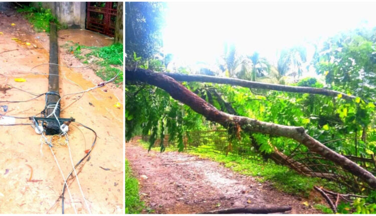
As warned by the IMD, Barak Valley has witnessed rains throughout the day, coupled with strong breeze. Reports of a tree getting uprooted in Katigorah have surfaced. Several poles connecting electric wires have also tumbled down. Tonight is the night of Kali Puja. Puja Committees across the three districts are spending worrisome times, especially the big budget ones.
This, according to the meteorological department, is an impact of the Deep Depression over the east-central Bay of Bengal. This also comes with the ‘Sitrang’ on the backdrop.

IMD, Ministry of Earth Sciences, Government of India has today issued a press statement which informed, “The cyclonic storm “SITRANG” pronounced as “Si-Trang” over northwest and adjoining central Bay of Bengal moved north-northeastwards with a speed of 28kmph during past 06 hours & lay centered at 1730 hours IST of today, the 24th October over north Bay of Bengal. It is very likely to continue to move north-northeastwards and it is likely to cross Bangladesh coast between Tinkona Island and Sandwip close to Barisal during midnight of today and early hours of tomorrow, the 25th October, 2022.”
It added a warning for the affected states and it included, “Northeastern States: Light to moderate rainfall at most places with heavy to very heavy rainfall at isolated places is likely over North Assam, Arunachal Pradesh, Nagaland & Manipur; heavy to Extremely heavy rainfall likely over South Assam, Meghalaya, Mizoram, & Tripura on 24th October. Light to moderate rainfall at most places with isolated heavy to very heavy rainfall is likely over Arunachal Pradesh, Assam, Meghalaya, Mizoram, & Tripura on 25th and isolated heavy rainfall is likely over Arunachal Pradesh, northeast Assam and Nagaland on 26th October.”
There is a wind warning too and that includes South Assam among the list of highly affected zones. Squally wind speed reaching 40-50 kmph gusting to 60 kmph is likely over Mizoram & Tripura from tonight. It would increase gradually becoming wind speed reaching 50-60 kmph gusting to 70 kmph over Tripura and 45-55 kmph gusting to 65 kmph is likely over Mizoram, south Assam and adjoining east Meghalaya & Manipur during early hours to afternoon of 25th October and decrease thereafter gradually.”
There are special precautionary measures advised for South Assam in Government of India’s Mausam bulletin.
Damage expected over Tripura, Mizoram, Meghalaya, Manipur and South Assam
Damage to standing crops including agricultural and horticultural crops due to heavy rain and squally winds
Breaking of tree branches and uprooting of small tress like drumsticks, banana and
papaya trees
Inundation/localized flooding in low lying areas due to heavy rains
Localized landslides/ mudslides/ mud slips/ mud sink possibility due to heavy rain
Traffic may be disrupted due to poor visibility in association with heavy rain
Vulnerable structures like hoardings, tents and display boards may be damaged
Action suggested for Tripura, Mizoram, Meghalaya, Manipur and South Assam
People are advised to be cautious while going outside
Regulate traffic
People should not move nearby to vulnerable structures
Comments are closed.